• You can now help support WorldwideDX when you shop on Amazon at no additional cost to you! Simply follow this Shop on Amazon link first and a portion of any purchase is sent to WorldwideDX to help with site costs.

Hurricane Forecast 2009


The Hurricane forcast is both good and bad for me.....

It's good because I live on the South Jersey coast, and they tend to do a lot of damage to things like homes, and amateur radio antennas, besides severely disrupting the fishing....

It's bad because most of these storms take a big sweeping turn, ride up the warm waters of the deep sea canyons, then dissipate far up in the north Atlantic, this keeps them far enough off shore to not cause any damage, but generates some quality surfing conditions for a normally wave starved east coast......
 
hope so, CHARLIE made landfall 1/4 mile from my house, the eye went over me. there were 6 houses on my culedesac, mine is the only one still standing.:eek::eek:
 
hope so, CHARLIE made landfall 1/4 mile from my house, the eye went over me. there were 6 houses on my culedesac, mine is the only one still standing.:eek::eek:

I got hit with Hurricane Lili when I lived in Lafayette, La back in 2002. She dropped a Pecan tree through my house. Got the house fixed and let my brother move in with my parents. Life goes on.

Moved to Burus, La in 2003 to be closer to a deep water port that I was working out of. The eye of Hurricane Katrina made landfall there. I never saw my home again. We evacuated back to the house in Lafayette, La along with 28 of my other relatives from the New Orleans area. Needless to say it was over crowded so we decided to go and live at our camp in Cameron, La.

One week after we moved into the camp and three weeks after we lost everything we had in Buras, La Hurricane Rita came calling. Again, a direct hit. We never saw our camp again. So we went back to our house in Lafayette along with the rest of the family. We added on another 1200 square feet and life went on.

Eventually we rebuilt the camp in Cameron and life was getting back to normal until September 2nd of 2008. Hurricane Gustav came through Lafayette with another direct hit and again another tree fell through the addition. This time a water oak. Ok, back to the camp in Cameron until we can get the house fixed again.

BUT NO............Yet again like clock work, three weeks later again here comes another storm. Hurricane Ike. We evacuate back to Lafayette and rent an RV to park in the driveway. Storm surge of 20' hits Cameron and we never see our camp yet again.

We have now purchased another house in Lafayette just a few doors down from our other one. My parents and brother still live there. We cut down all the remaining trees and have installed a Guardian Generator. My new home however is surrounded by trees. Hopefully they will stay up in the air.

In roughly 6 years I have lost everything I own 3 times. When I say to never see anything again I mean it. Only a foundation remaining.

Life goes on in the BYU. People ask me why I don't move. With the way storms follow me around would you want me living near you?
 
MAN...... i thought i had it bad ...LOL

I lived just north of Baton Rouge LA most of my life... had a few storms come thru..that i can remimber... Andrew being the big one

Still have many good life long friends around Zachary La... they got hit pretty hard from Katrina and Rita...


any way......
moved to Houston in around 95....... a few storms here and there.


THEN.........................IKE came 7 months ago .. almost to this day

I'm still working on this house............. most in my area can't rebuild... total loss


HurricaneIke018.jpg


HurricaneIke130.jpg
 
first off, these LONG RANGE hurricane forecasts need to be taken with a grain of salt...period....anyone can pull out numbers based on climo & analogs yrs & averages....

long range forecasting can be tricky, you have to take it one storm at a time, but one needs to learn the WX basics & storm formation(what causes storms) before jumping into Teleconnections & occilations(MJO) and ENSO(el-nina/nino) diagnostic forecasts,upper atmosphere data, numerical wx models and the more advanced stuff,CPC/NOAA

one thing i can tell you is....when June 1st arrives take a look at upper level wind shear or pattern over the tropical Atlantic,check the TCHP(tropical cyclone heat potential) for the Atlantic basin,then check the ITZC(inter-tropical convergence zone) for active tropical waves along that zone or waves from African coast, then check the Madden -Julian oscillation for the Atlantic basin, check the long range forecast models every run....:laugh:

tropical wave + low wind shear + really warm SST + strong negative MJO phase = moderate to high probability of storm formation and will almost always yield a formidable tropical system...then all you do is monitor steering currents and so on.....

here is a few good sites for hurricane season....

TROPICAL ATLANTIC e-WALL

Tropical Weather Information Crown Weather - Your One-Stop Weather Information Source - US Weather, Tropical Weather, and More!

Tropical Cyclone Heat Potential Page: Global Fields

CPC - Climate Weather Linkage: Madden - Julian Oscillation

Tropical Atlantic: Information About Atlantic Hurricanes
 
here is a prime example of what i mentioned in my previous post....:D

todays 00Z GFS showing negative MJO phase over the carribean & GOM during 5-15 day time period.....

gfs.gif


now here is an image from the 06Z GFS(SLP/6hr precip) @384hr(may 12th)showing a formidable tropical system moving towards the GOM....:eek:

2009042606_SYS_GFS_SFC_SLP_THK_PREC.gif


SST's & THCP is low ,wind shear should be high, so i give this a relatively low probability of any actual development, if development is still being shown as a possiblity on the numerical WX models a week from now or on a consistant basis, once we get within a week or so it may be interesting , but then again it could be a total NON_ISSUE for anyone in the US.....

this is also a rather ironic example of what i mentioned earlier,using some of the basic tools i mentioned above and you could spot tropical systems before the local news mets even have a clue or the balls to talk about ....laugh:could be very useful for those in hurricane prone or vunerable areas...
 
Life goes on in the BYU. People ask me why I don't move. With the way storms follow me around would you want me living near you?

Man I only had to rebuild once. But like I told my wife, When you live here, trees are bad news. If it can fall on your home cut it down and burn the darn thing.
Oh yea Please don't move to Kenner. ;)
 
all you gulf coast guys , keep an eye on the tropics, there could be storm to watch between this weak(may 19th-23 or 26)...

the globals forecast models have been to showing the area of disturbed WX near cuba should combining with an upper low/frontal boundry sinking south into the caribbean, giving us what i assume to be mainly an extra-tropical system...if the shear relaxes enough due the the ridge axis and high set-up to the North there could be a slight possiblity it becomes more organized and is classified sub-tropical....

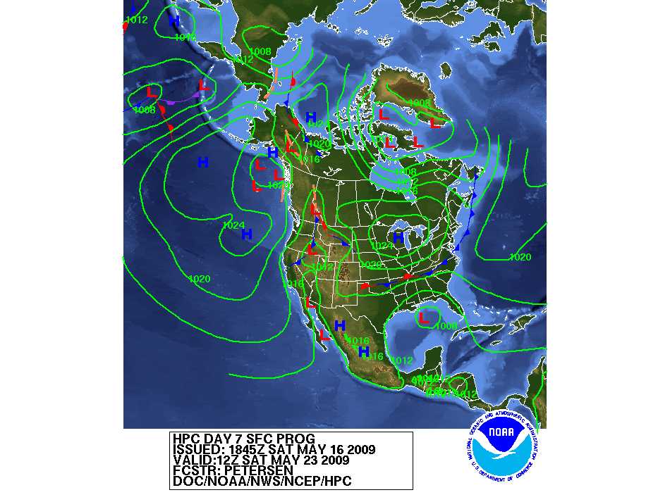
nothing to exciting but something to track....the model agreement is there as far as the storm being shown, just sorting out track & intensity really...the CMC/GGEM model has had the deepest pressures so far,the OP GFS is on the fence and the ECMWF is the low end of the pressures that last few runs....the HPC came up with a blend of 12Z UKMET/GFS/ECMWF for todays day 3-7 surface chart,which IMO from what Ive seen so far seems reasonable...this should be watched, as there is certainly time for it to get more interesting.... smile.gif

here are some of the latest infos/models on this storm potential....

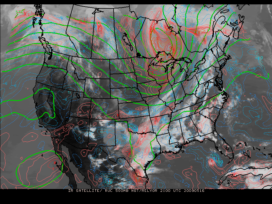
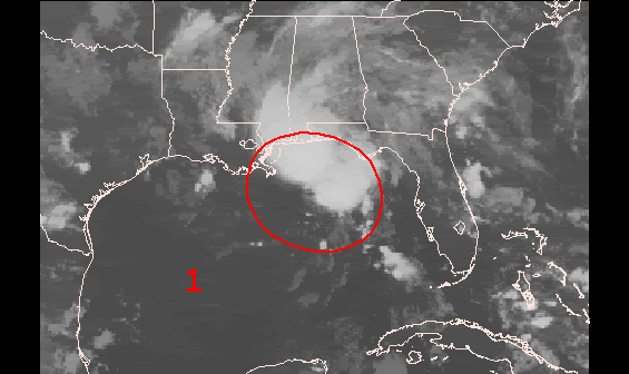
here is the current 500mb showing the 2 areas of disorganized energy that is being progged to colide, one over east TX(+ frontal boundary) one the other area around cuba....

sat500_18-2.gif


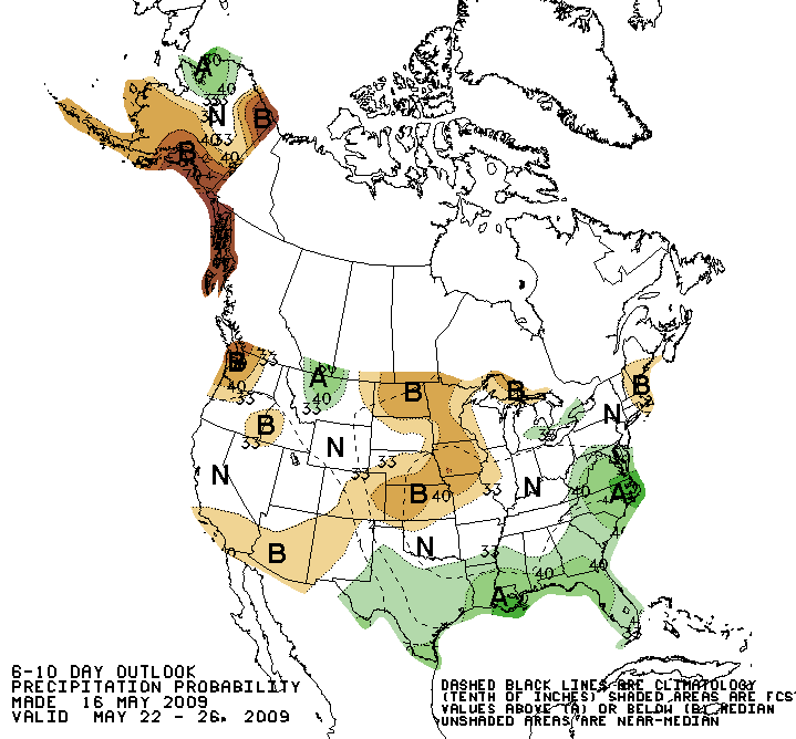
todays CPC forecast precipitaion for may 22-26
610prcpnew.gif


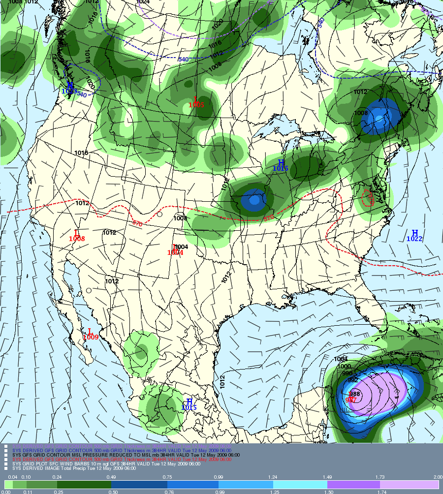
todays HPC surface chart for Day 7
9nh.gif


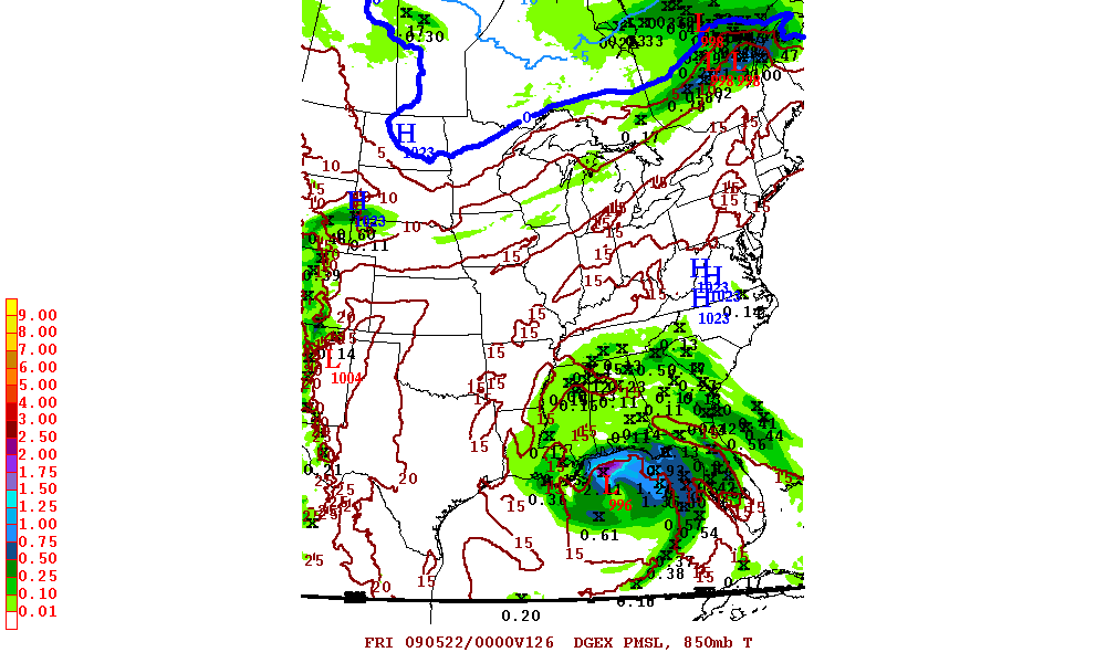
todays 18Z hi res DGEX model @126hrs out or (may 22 12AM EST)
18zdgex850mbTSLPp06126.gif
 
as you can see above ,last Saturday i mentioned the possibility of a storm impacting the gulf coast....well here we are, lets have a look

2AM NHC update

atl1.gif


SPECIAL TROPICAL WEATHER OUTLOOK
NWS TPC/NATIONAL HURRICANE CENTER MIAMI FL
155 AM EDT SAT MAY 23 2009

FOR THE NORTH ATLANTIC...CARIBBEAN SEA AND THE GULF OF MEXICO...

1. SATELLITE IMAGERY...RADAR DATA...AND SURFACE OBSERVATIONS INDICATE
THAT THE AREA OF LOW PRESSURE CENTERED OVER THE NORTH CENTRAL GULF
OF MEXICO ABOUT 150 MILES SOUTH OF MOBILE ALABAMA CONTINUES TO SHOW
SOME SIGNS OF ORGANIZATION. ADDITIONAL DEVELOPMENT OF THIS SYSTEM
IS POSSIBLE...AND IT COULD BECOME A TROPICAL DEPRESSION AT ANY TIME
BEFORE MOVING INLAND OVER THE NORTHERN GULF COAST LATER TODAY. AN
AIR FORCE RESERVE HURRICANE HUNTER AIRCRAFT IS SCHEDULED TO
INVESTIGATE THE LOW LATER TODAY...IF NECESSARY. THERE IS A HIGH
CHANCE...GREATER THAN 50 PERCENT...OF THIS SYSTEM BECOMING A
TROPICAL CYCLONE BEFORE IT MOVES INLAND WITHIN THE NEXT 24 HOURS.
REGARDLESS OF DEVELOPMENT...HEAVY RAINS AND OCCASIONALLY GUSTY
WINDS ARE EXPECTED ALONG PORTIONS OF THE NORTHERN GULF COAST
THROUGH THE DAY...AND INTERESTS IN THIS AREA SHOULD MONITOR THE
PROGRESS OF THE SYSTEM.

ANOTHER SPECIAL OUTLOOK ON THIS SYSTEM WILL BE ISSUED LATER THIS
MORNING...IF NECESSARY.
 
Yeah buddy, you nailed that one on the head. Hey, when did you get so smart? Didn't I talk to your girlfriend on the nextel once? Is this the same Mac292 from the ol days with T2W?

Well whatever you are doing in life I hope it involves meteorology. Nice call.
 
Yeah buddy, you nailed that one on the head. Hey, when did you get so smart? Didn't I talk to your girlfriend on the nextel once? Is this the same Mac292 from the ol days with T2W?

Well whatever you are doing in life I hope it involves meteorology. Nice call.

lolz...yup,that be me, you probably did, goodtimes back then...

i dumped(put away for the time being) my CB junk and and found some new hobbies in severe WX(tornadoes/hurricanes/winter storms)back in '03-'04 ,also DIY pc build is another hobby i picked up a few yrs ago....some aspects are rather complex, but for the most part an understanding of WX basics,and links to models,are a mustetc....the computer models did fairly well since it was a weak system, and the synoptics did not shift drastically...this system would have been stronger if the ULL was not involved....as far as the foreseeable future, there are currently no storms on the horizon after the GOM bird fart,but if something arises i'll pop back in and give yall a head ups....;)
 
Last edited:

dxChat
Help Users
  • No one is chatting at the moment.